 Filter: Categories of Wisconsin Historical Images
Filter: FORMAT_DIMENSIONS of 46 cm
Filter: Categories of Wisconsin Historical Images
Filter: FORMAT_DIMENSIONS of 46 cm
| Date: | 1908 |
|---|---|
| Description: | The original caption reads: "A biographical sketch of this subject is given in Volume IV, page 204." A waist-up portrait of a man in profile. |

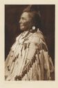
| Date: | 1903 |
|---|---|
| Description: | The original caption reads: "A representative type of the Mohave men." From "The North American Indian," the multi-volume set in which Curtis attempted to ... |
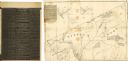
| Date: | 1838 |
|---|---|
| Description: | This map of the Wisconsin Territory, accompanied by the photostat of an article from the January 13, 1838, Wisconsin democrat, shows the area described as ... |

| Date: | 1905 |
|---|---|
| Description: | A geological survey map of southeastern Wisconsin, showing Pleistocene-era deposits, including drifts, moraines, drumlins and deposits from various glacier... |

| Date: | 1941 |
|---|---|
| Description: | A map of the area south of Ripon and Sheboygan and east of Waterloo and Janesville, showing the route of the Chicago, North Shore and Milwaukee Railroad in... |
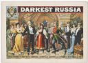
| Date: | 1895 |
|---|---|
| Description: | Color lithograph poster showing a scene set at a musical recital in Imperial Russia. Top left inset with Imperial Russian crest and "by H. Grattan Donnelly... |
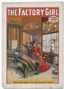
| Date: | 1903 |
|---|---|
| Description: | Color lithograph poster. "The Factory Girl" in red banner across top. “A Great Labor Play” under title top right. Scene depicting a well-dressed woman whee... |

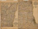
| Date: | 1883 |
|---|---|
| Description: | A hand-colored map of Wisconsin showing counties, cities, villages, railroads, lakes, and rivers in the state. The map also includes the eastern portions o... |

| Date: | 1874 |
|---|---|
| Description: | This map shows lands in the vicinity of the railway route between St. Paul and Chicago, extending from Valley Junction (labelled Wisconsin Valley Junction ... |

| Date: | 1906 |
|---|---|
| Description: | A hand-colored map of Wisconsin identifying the railroads, counties, cities, rivers, and lakes in Wisconsin, eastern Minnesota and Iowa, northern Illinois,... |
| Date: | 1907 |
|---|---|
| Description: | The first map shows the area from Milwaukee north to Green Bay and west to Columbus; the second map displays the area between Chicago and Milwaukee and wes... |
| Date: | |
|---|---|
| Description: | Hand-drawn map of the town of Cadiz, Wisconsin near the Illinois border showing plots of landownership. The map also includes one landmark of the Pecatonic... |
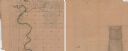
| Date: | 1850 |
|---|---|
| Description: | A hand-drawn plat map of the area along the Pecatonica River in the Town of Cadiz, Green County, Wisconsin. |
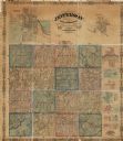
| Date: | 1862 |
|---|---|
| Description: | This map shows townships, landownership, roads, railroads, and swampland in Jefferson County. There is an inset maps showing the towns of: Watertown, Jeffe... |

| Date: | |
|---|---|
| Description: | A brochure and map of Jefferson County, Wisconsin, which includes color illustrations, a highway map of the county, a location map, and descriptions of poi... |

| Date: | |
|---|---|
| Description: | A brochure and map of Jefferson County, Wisconsin, that includes illustrations and a location map. Descriptions of points of interest are printed on the op... |

| Date: | 1969 |
|---|---|
| Description: | A map of the Elroy-Sparta State Trail and the surrounding area, showing the townships, the towns of Cashton, Sparta, in the west, and Union Center and Elro... |
If you didn't find the material you searched for, our Library Reference Staff can help.
Call our reference desk at 608-264-6535 or email us at:


